

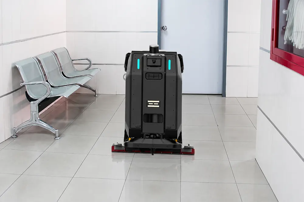
How does a cleaning robot map a building? A cleaning robot maps a building using 3D LiDAR, cameras and other sensors that collect data about walls, columns, shelves and passageways. SLAM technology simultaneously creates a digital map of the space and determines the robot’s position within it, while the operator then defines cleaning zones, restricted zones and planned routes on that map.
The map is therefore more than just a digital floor plan of the building. It provides the foundation that the robot uses to link its current position to the zones where it needs to work and the route it needs to follow.
Mapping and localisation are only one part of the system that enables autonomous operation. The guide to commercial cleaning robots. explains in greater detail how these technologies work with sensors, navigation and the floor maintenance process itself.
How does a cleaning robot map a building and which sensors does it use?
The robot combines at least three types of sensors to create a reliable map: 3D LiDAR for precise distance measurements, depth cameras for object recognition, and ultrasonic or infrared sensors for surfaces that LiDAR and cameras find difficult to detect, such as glass or reflective metal.
- 3D LiDAR: sends laser pulses in all directions and measures how long the signals take to return, allowing it to determine the exact distance to walls, shelves, columns and other obstacles. It serves as the primary sensor for creating the map. This precision is particularly important for reliably mapping narrow passageways and hospital corridors in models designed for demanding, busy environments, such as the CenoBots L3, which uses 96-channel 3D LiDAR.
- Depth cameras: add visual depth to the space, helping the robot distinguish stationary obstacles from moving ones during subsequent operation on the completed map.
- Ultrasonic and infrared sensors: detect transparent or reflective surfaces, such as glass partitions, shop windows and metal shelves, which cameras and LiDAR may not always detect reliably.
What is SLAM and what role does it play in mapping?
SLAM (Simultaneous Localisation and Mapping) allows the robot to build a map of the space and determine its own position within it at the same time. Mapping and localisation are therefore not separate steps. To reach a specific zone autonomously, the robot must continuously link spatial data with information about its current location.
In CenoBots robots, 3D LiDAR plays a crucial role in this process by providing precise distance measurements to surrounding elements. Once the robot creates and saves the initial map, it can use it for subsequent tasks. Therefore, the robot does not need to map the entire space before every cleaning cycle. Some models also handle situations in which the robot temporarily loses its exact position within the map. For example, the CenoBots SP50 can automatically resume work from its last known location. This feature proves particularly useful in long, uniform corridors, where the robot can lose its orientation more easily.
How does the robot plan a cleaning route after creating the map?
Once the robot has a map of the space and knows its own position, the navigation system plans a path through the designated cleaning zones. The robot must do more than simply travel from one point to another. It must organise its passes so that it covers the assigned area systematically while minimising unnecessary repetition.
It is therefore important to distinguish the map from the route. The map describes the space in which the robot operates, while the route defines how it will move to complete a specific task. For this reason, the robot does not always choose the shortest path.
The shortest path between two points does not necessarily provide the best route for systematic cleaning. The robot considers the boundaries of the assigned zone and the required floor coverage, so the planned path may sometimes appear longer than a direct route to the destination. This happens because complete surface coverage takes priority over speed.
How does the operator define the zones that the robot needs to clean on the map?
After the robot creates the map, the operator uses it to define the zones where the robot needs to perform tasks, as well as the areas it must avoid. The robot then combines this information with the map and its current position to plan movement exclusively within the assigned space.
The same map can therefore support different tasks. The robot does not need to cover the entire building every time it starts. The operator can assign a task to only one zone or part of the mapped space, while the system retains the rest of the map for subsequent operating cycles.
Does a change in the building’s layout always require remapping?
No. During operation, the robot uses its sensors to detect temporary changes, such as a person walking through a passageway, an unattended trolley or a pallet blocking its path, and adapts its movement to the current conditions without recreating the entire map. More permanent changes, such as relocated shelves or new partitions, may require updates to the existing map or zones.
Models that support automatic map updates, such as the CenoBots L50, handle part of this process autonomously. The robot adjusts its internal map when staff rearrange products on shelves, without requiring a complete remapping of the building.
The saved map therefore does not need to include every person, trolley or other temporary obstacle because the robot uses its sensors during operation to detect people and obstacles that currently appear in its path.
Does every CenoBots model use the same mapping process?
Not entirely. All models use the same basic principle: LiDAR, sensors and SLAM. However, the number of LiDAR channels, detection range and additional mapping capabilities vary between models, depending on their intended purpose and the size of the space for which they were designed.
- CenoBots L3: uses 96-channel 3D LiDAR, the most advanced in the range, adapted for precise mapping of narrow passageways, hospital corridors and busy retail spaces.
- CenoBots L4: uses 32-channel 3D LiDAR with a detection range of up to 150 metres, sufficient for mapping medium-sized commercial spaces with numerous edges and fixed elements.
- CenoBots L50: also uses 32-channel 3D LiDAR with a range of up to 150 metres, but additionally supports automatic map updates when products on shelves or displayed items move, without requiring a complete remapping.
- CenoBots S5: uses 32-channel 3D LiDAR with the same range (150 metres), adapted for mapping large industrial spaces such as warehouses and logistics centres.
- CenoBots SP50: uses 32-channel 3D LiDAR with a range of up to 150 metres and can also automatically resume work from its last known location if it temporarily loses its exact position within the map, which proves particularly useful in long, uniform corridors.
Table: When does the robot’s map require adjustment?
| Change in the building | Impact on the existing map | Required action |
| A person walks through the cleaning zone | Does not change the underlying map | The robot detects the person during operation and adjusts its movement |
| A trolley or pallet temporarily blocks a passageway | Does not require changes to the underlying map | The robot responds to the temporary obstacle while performing the task |
| Furniture or equipment has been moved temporarily | Usually does not change the basic structure of the space | The robot uses sensors to monitor current conditions |
| Shelves have been permanently relocated | May change the available passageways | The operator needs to check and, if necessary, adjust the map, zones or routes |
| A new partition has been installed | Changes the geometry of the space | The map or the configuration of the relevant zone may require an update |
| The purpose of part of the building has changed | The geometry itself may remain unchanged | The operator can change the cleaning zones, restrictions or tasks |
Why are mapping and route planning important in commercial buildings?
Mapping and route planning allow the robot to move systematically through large and complex commercial spaces, such as shopping centres, hospitals, hotels, airports, factories and warehouses. Such buildings contain different zones and changing conditions, and require robots to perform cleaning tasks consistently according to a predefined plan rather than at random.
By combining data from the map, localisation and planned path, the robot links the digital representation of the space with a specific cleaning task. This allows a mapped building to provide the basis for daily autonomous operation, instead of requiring the robot to repeat the mapping process before every task.
Through its F45 Committee on Robotics, Automation and Autonomous Systems, ASTM International develops standards and test methods for the navigation and localisation of autonomous mobile vehicles and robots, including standardised methods for testing movement through a defined space.
How does a cleaning robot map a building? – FAQ
Does the robot decide which parts of the building it will clean?
Not in the sense that it sets cleaning priorities for the business. The operator defines zones and tasks on the map, while the navigation system autonomously plans and executes movement within those rules. The operator specifies in advance what the robot needs to clean, and the robot determines how to move through the assigned area.
Is the robot’s map the same as the building’s construction plan?
No. A map designed for autonomous navigation contains the spatial information the robot needs for localisation, movement and task execution. It does not replace an architectural plan. Instead, it allows the navigation system to identify the layout of relevant elements and the relationships between the zones through which the robot needs to move.
How long does the initial mapping of a building take?
The time depends on the size and complexity of the space, but the process generally takes significantly less time than defining a route manually. LiDAR scans the space automatically, and the operator then only needs to define zones and restrictions on the completed map.
Does the robot’s map contain recordings or photographs of the space?
Not in the conventional sense. A LiDAR-generated map provides a geometric representation of the space. It consists of data about the distances, shapes and positions of walls, shelves and obstacles, rather than photographic or video footage. The robot uses cameras to identify obstacles and objects in real time during operation. However, the saved map of the building does not generally constitute a visual recording of the space. Instead, it contains structured spatial data required for navigation.
The map can show the robot where it is, but the right solution begins with understanding the space in which it needs to work. If you are considering how autonomous cleaning could work in your building, we can start with your space and determine together what makes the most sense for it.
About the author:
Milja Tonić – SEO Content Strategist & Copywriter
Milja Tonić is an SEO Content Strategist and Copywriter who specialises in creating expert content on facility management, professional commercial property maintenance and the automation of cleaning processes.
Through research, SEO strategy and original writing, she develops content on professional hygiene, facility management and the use of autonomous cleaning robots in various commercial environments.

0 Comments